*** Drones help identify post-Hurricane Matthew needs in Haiti | THE DAILY TRIBUNE | KINGDOM OF BAHRAIN

Drones help identify post-Hurricane Matthew needs in Haiti

Jérémie : On a football field in the Haitian town of Jeremie, children gather to gape at a drone preparing to take off and document damage to the area caused by Hurricane Matthew.

The powerful storm, which crashed ashore on October 4 packing winds of 145 miles (230 kilometers) per hour, focused its fury on southwestern Haiti where this coastal city of some 31,000 is located.

At least 546 people were killed during the hurricane and more than 175,000 people lost their homes.

Many people in Jeremie are still waiting for help to arrive nearly three weeks later, but relief workers now have a powerful new tool to pinpoint where aide is needed.  

Haitians with the group Potentiel 3.0 traveled to Jeremie with a flotilla of four drones to document the damage.

"Before, satellite images could be used" for this purpose, "but the resolution was not perfect," said Presler Jean, who remotely controls one of the drones from his laptop.

"With the drones, one has absolutely all the details of the covered area," he said.

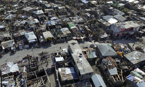
Homes reduced to matchsticks, a building with a blown-off facade or a roof missing two or three shingles: no detail escapes the eye of the drone. 

Drones can gather enough information to develop three-dimensional images with precision of four centimeters (1.6 inches) -- a giant leap from the roughly 50-centimeter (19.7 inch) detail provided by satellites.

Thanks to drone imagery, engineers were able to quickly repair Jeremie's storm damaged harbor, allowing the first aid ship to dock 72 hours after the hurricane hit, said Fred Moine, head of the volunteer group.

Within just a few hours, "Heavy machine operators knew exactly how much sand was needed" for harbor repairs, he said.

article-image

Haitian expertise 

Faster and a lot cheaper to operate than helicopters, drones are piloted from the ground by Haitians like Presler, 30, who has been working with the devices since 2012.

Presler remembers the devastation caused by themassive earthquake that struck Haiti in January 2010 -- and especially how much of the international aid that flooded in went to waste through mismanagement.

"Before the foreigners get here, we Haitians have time to produce images that they can use. This will allow the aid to flow a bit faster," said Presler. 

"And instead of resources wasted on evaluations and project studies, those funds can instead be used for durable buildings," he said.

More than 200,000 people were killed in the earthquake, and only a fraction of the poorly coordinated international aid that poured in reached the victims.

The drones are also ideal for surveying the needs of isolated communities in mountainous regions that are hard to reach by land.

"There are plenty of competent Haitians, we no longer have to wait for the international community," said Presler.

"We can use our skills together to provide a quick response for our country," he added with pride.

Potentiel 3.0 hopes to train enough people so there can be two or three drone pilots for each of Haiti's ten departments.

"That way, Haiti can finally respond with its own resources to disasters," said Presler, as he turns to his laptop to guide the drone.

In addition to the destruction of countless homes and farms, Haitians in the worst-affected areas are dealing with a lack of potable water, which is contributing to the spread of cholera, which has claimed close to 10,000 lives since it first appeared in 2010.

Following the devastation caused by Hurricane Matthew, nearly 1.5 million people, of a total population of 10.3 million, need emergency humanitarian assistance, according to a United Nations estimate.