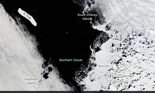
NASA satellite image shows world's largest iceberg heading to its doom
Agencies | Washington
The Daily Tribune – www.newsofbahrain.com
In a new satellite image revealed by American space agency NASA, Antarctic iceberg A-76A, the biggest remaining piece of what was once the largest iceberg, could be soon heading towards its demise.
As per the US National Ice Centre, the iceberg is 135 kilometres long and 26 kilometers wide (measured in June 2021) - an area equal to about twice the size of London.
It is the biggest chunk of the Rhode Island-size A-76, the previous largest iceberg in the world, which broke off from the western side of the Ronne Ice Shelf in Antarctica in May 2021 and later split into three pieces: 76A, 76B, and 76C, Live Science reported. Iceberg 76A is the largest among these pieces.
It was slowly drifting along the Antarctica for more than a year, but its melting has accelerated now and the iceberg is heading for its eventual demise, the outlet further said.
A-76A was photographed on October 31 by NASA's Terra satellite, in its natural-colour image, as it floated in the mouth of the Drake Passage, a narrow strait connecting the Pacific and Atlantic oceans between Cape Horn in South Africa and the South Shetland Islands to the north of the Antarctic Peninsula. The iceberg is currently visible in the image between Elephant Island and the South Orkney Islands, which are both hidden by clouds, at the southern end of the route, but its path suggests that it may soon move farther north into the canal. The picture was published online by NASA's Earth Observatory on November 4.
NASA said, "Icebergs are not sea ice; they are the floating fragments of glaciers or ice shelves, whereas sea ice is frozen seawater that floats on the ocean surface."
"It remains to be seen where A-76A will drift next. It is already more than 500 kilometers north of its position in July 2022, when the European Space Agency's Sentinel-1 satellite showed the berg passing the Antarctic Peninsula," the space agency further said.
Related Posts

